Radcot to Tadpole Bridge
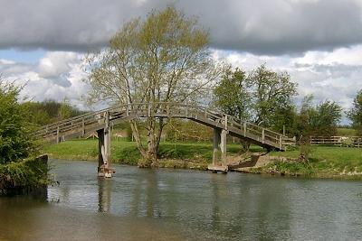 Old Man's Bridge
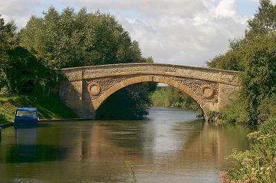
This area of Oxfordshire is very flat, with the result that even minor intrusions into the skyline seem to have a more striking effect than they would otherwise merit. Even making allowances for the terrain the curved outline of Old Man’s Bridge stands out impressively against the grey skies as I walk towards it.
In days gone by there used to be a weir at this spot. It was known as Old Man’s Weir, or sometimes alternatively as Harper’s Weir. This weir was in a very convenient location for travellers wishing to pass between Faringdon on the south side of the river and Bampton on the north, and it became a popular crossing point. When the weir was removed in the mid 1800’s a footbridge was built to preserve the right of way across the water. The original bridge fell into a state of disrepair and was replaced by the present bridge in 1894.
The bridge itself is steep and very narrow with only enough width for a single person. Presumably this was to prevent traders from using this bridge for carts and thus enabling them to avoid the tolls at the main bridges further upstream at Radcot.
Old Man’s Bridge is seemingly in the middle of nowhere, and its loneliness adds to the beauty. There is a certain ambience to this location and everything seems to fit together perfectly. I sit for a while to absorb the atmosphere and watch the waters glide beneath the wooden structure, the reflection adding to the symmetry of the scene.
Some old friends return as I step along the pathway. The meanders are back; and back in style. Together we twist and loop and turn, performing a choreographed dance across the meadows. Somewhere ahead is Rushey Lock, but is it in front or to the left or the right? The river moves left and right in deception and appears to be deliberately inducing a sense of giddiness until suddenly I cross the weir and arrive at Rushey Lock.
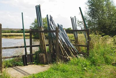 Paddles at Rushey Weir
The weir at Rushey is of the old style “rhymer and paddle” construction, and the old paddles are stacked against the fence immediately before the weir. As I cross the weir the handles of the submerged paddles can be clearly seen on my left. This is one of the last weirs of this design still in use today.
Rushey Lock is very well kept with bright flower gardens and a superb foliage frog in the middle of the lawn, with its bulbous blue eyes keeping watch over the lock. I almost trip over the similarly constructed floral snail standing beside the lock-keeper’s wooden hut.
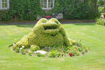 Frog at Rushey Lock
After the gyrations of the previous section it is disappointing to find that the next stretch follows the lock access road in a relatively straight line to Tadpole Bridge. It is starting to rain as well. This would normally dampen my spirits, but a key destination point lies at the end of the track, then it can rain all it likes for a while. I am nearing the Trout Inn at Tadpole Bridge and that means lunch.
Tadpole Bridge itself is a bit of a disappointment. After the fine old stone bridges I have encountered upstream this one is rather plain. A simple single span standard stone bridge that is purely functional with none of the medieval beauty of Radcot or Lechlade.
In complete contrast immediately next to the bridge is the Trout Inn. This inn is everything that the bridge is not. Elegant and stylish, it also exudes a rustic charm that gives it a unique character.
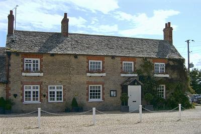 Trout Inn, Tadpole Bridge
The Trout has so many listings in various “good food and drink” guides that it seems almost ill-mannered to ask for a baguette. But rather like the adverts for Marks & Spencer’s, this was no ordinary baguette; it is a Trout Inn baguette. A Thai sticky beef curry baguette to be precise. Delicious.
Suitably refreshed it is time to move on. The rain has momentarily stopped so that when I leave the cheerful bar of The Trout it is into that refreshing ozone-filled air that exists after the rains have stopped. Combined with the satisfaction of a very tasty lunch this gives me a “feel-good” high and I stuff the waterproof into my pack and look forward to the afternoon. Invigorated I walk on, but it is only a short while before the rain comes again and the waterproofs are pulled back out to resume their duties that last for the remainder of the day.
 Downstream of Tadpole Bridge
The path runs alongside the edge of one of the largest areas of natural meadowland in Britain. Chimney Meadow Nature Reserve covers 250 hectares of wildlife rich land and is managed by the Berks, Bucks and Oxon Wildlife Trust. The wetland supports large numbers of ground-nesting birds, and is a haven for rarer wading birds. Redshank, curlew and snipe have all been spotted here. The area is threaded with old waterways and hedgerows. The Trust has a program to restore more wildlife to Chimney Meadows over the coming years.
Tenfoot Bridge is a slightly smaller version of Old Man’s Bridge. It is another narrow, lonely footbridge apparently situated in the middle of nowhere. Why Tenfoot Bridge when it is twelve feet high? Well, in similar manner to its look-alike the footbridge stands in a position that until 1870 was formerly occupied by a weir. This was referred to as Tenfoot Weir because when the paddles were removed the gap was ten feet wide.
< Previous Page | Next Page >